Interview
Comparing flood forecasting and early warning systems in the Benelux+ region
We spoke to Tim Busker and Jeroen Aerts from the Institute for Environmental Studies (IVM) in VU Amsterdam about their upcoming research carried out in the scope of our programme.
Jeroen Aerts


Tim Busker
Meet Prof. Dr. Jeroen Aerts
Jeroen Aerts, is a Professor of Water and Climate Risk, at the Institute for Environmental Studies (IVM) at VU University Amsterdam. He studies the interactions between the physical water system and flood management within quantitative flood risk assessment, with a special interest in flood adaptation to climate change. His research has improved our understanding of hydrological processes and flood extremes but also on which socio-economic factors play a role in driving flood risk.
For example, population growth and urbanisation in low-lying areas will increase losses, even if the climate remains unchanged. More recently, flood risk models have been extended to address complex behavioral feedbacks. For instance, most large-scale flood management interventions were implemented after major disasters, when risk perceptions and societal support were high. Socio-hydrology research examines these feedbacks and how the water system and its hydrological processes are interconnected with societal systems.
In JCAR ATRACE, Jeroen’s group will demonstrate the use of coupled ‘hydrological and agent-based models’ (ABMs) to simulate these feedbacks assuming climate change scenarios. In ABMs, agents can learn, move, and influence (and be influenced by) the flood risk they face, leading to the implementation of various adaptation actions. ABMs can also be used to explore the limits of future flood adaptation.
Prof. Dr. Jeroen Aerts
Professor of Water and Climate Risk, Institute for Environmental Studies (IVM) at VU Amsterdam

Tim Busker
Tim Busker is a Postdoctoral Researcher at the department of Water and Climate Risk at the Institute for Environmental Studies (IVM) at the Vrije Universiteit Amsterdam. Tim has a background in flood and drought risk management, specializing in forecasting, remote sensing and risk analysis. During his PhD research, Tim further specialized in early-warning systems and anticipatory action for floods and droughts in multiple parts of the world.
As part of the JCAR ATRACE project, Tim works on a comparison study about the flood early-warning systems of the Netherlands and neighbouring countries. He also convenes two sessions at the EGU25 conference. Moreover, Tim works on flood modelling as part of a large team within the department and supervises several MSc and PhD students.

Tim Busker
Postdoctoral Researcher, Institute for Environmental Studies (IVM) at VU Amsterdam
Hi Tim & Jeroen, thank you for taking the time to speak to us. Could you tell the readers a bit about your work and the role of your institute?

Tim
Of course. I am a Postdoctoral Researcher focused on early-warning systems and anticipatory action for floods and droughts. Within the JCAR ATRACE programme, I lead the comparative study on Flood Forecasting and Early Warning Systems (FFEWSs) in the Benelux + region.
Tim
At the Institute for Environmental Studies (IVM), we model floods and the effect of adaptation options, such as nature-based solutions like retention ponds and reforestation and forecast-based actions such as placing flood barriers. My work involves forecasting floods and simulating processes using computer models, enhancing our ability to issue timely warnings and improve response strategies.
Tim
IVM is an interdisciplinary institute, integrating insights from climate, hydrology, individual behaviour, and policy. Our aim is to bridge the gap between natural processes and societal impacts, ultimately fostering better preparedness and interventions against floods and droughts.
Jeroen
I am a professor specialising in water and climate risk, my focus is particularly on extreme weather events, such as flooding. My research not only involves quantifying the risks associated with flooding but also exploring effective strategies to mitigate these risks. One crucial aspect of flood risk management is the implementation of early warning systems. Here in the Netherlands, for instance, we have infrastructures in place, such as dams and pumping stations, but there are numerous additional measures that can be taken to enhance flood resilience. Early warning is a vital component of this strategy.
Let's discuss your manuscript. Could you summarise it for us in a couple of sentences?

Overview of the study area, highlighting the catchments of the Geul, Vesdre, and Ahr in orange.
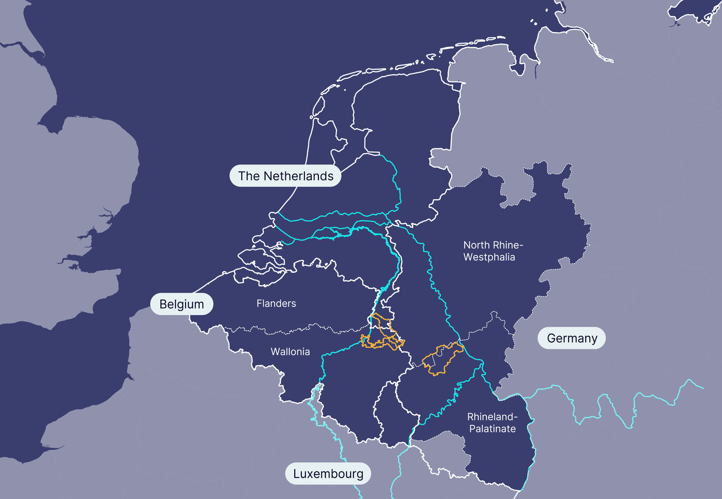
Overview of the study area, highlighting the catchments of the Geul, Vesdre, and Ahr in orange.
Tim
We did a comparative study of early warning systems for flooding across the Benelux countries and Germany’s federal states of North Rhine-Westphalia and Rhineland-Palatinate. While much existing research tends to concentrate on forecasting, our study takes an innovative approach by examining the entire warning-response chain. We aim to understand how early warnings translate into effective actions and identify the gaps that exist in this process. To gather insights, we conducted interviews with forecasters and crisis responders to assess the operational effectiveness of these systems across the different countries.
Jeroen
A recommendation that emerged is the need for warnings to go beyond just indicating rainfall or water levels. Experts suggest incorporating information regarding potential damage and expected impacts from forecasted floods. For instance, predicting a water level of three meters may not convey enough context. Are three meters concerning? Are four meters considerably worse?
Tim
Exactly. Crisis responders need specific insights, such as whether their fire station will be affected and if they can still access areas for emergencies. A two-meter water level poses different risks than three meters; if sandbags are only placed up to two meters, they will be useless at three.
Tim
Additionally, responders want insight into which hospitals and roads will likely be flooded. Information on the expected impacts of rising water levels is essential for their planning. Currently, Flanders has made strides in forecasting flood extent and depth, but clear thresholds for issuing warnings are still lacking. Overall, moving towards impact-based forecasting is vital. Crisis managers emphasise that this type of information is critical for their operations. However, forecast specialists highlight the challenges in providing such detailed insights.
Why did you start this research and what is your main message?
Tim
What really drove us to do this research was to test how well those operation systems function in different countries and consequently trigger a response. Here in the Netherlands, for example, we see that flood warnings do not always reach the population, partially due to the lack of a central organisation streamlining information into one clear message. We see communication fragmentation- we have the KNMI, which gives the meteorological warnings, the water boards, which give the small river warnings and Rijkswaterstaat for the large rivers. Adding to this, people can get warnings on the news and access information from the water board website. This leads to municipalities using different sources of information, which can make it hard to get a clear picture. We observed the same in the other countries and regions covered in the research. It would be interesting to follow up on these communication gaps in flood warnings by mapping out the different flows of communication in more detail.
Tim
For me, the main message is that there is a lot of potential to learn from each other as neighbouring countries, because the approaches are quite different.
Jeroen
My main message is that JCAR ATRACE can address this. Our PhD researcher Raffaella Gouveia Loureiro Oliveira is working to create a computer model that incorporates various aspects of flooding. This model will simulate forecasts based on historical data and potential future scenarios, detailing expected rainfall, flood levels, and the impact on infrastructure such as roads, hospitals, and police stations.
Jeroen
By sharing this information with policymakers, we hope to empower them to respond effectively and adapt the model based on their specific needs, such as estimating monetary damages. Throughout the project, we hope to continuously exchange information to optimise the forecasting process.
You investigate the differences in operational Flood Forecasting and Early Warning Systems (FFEWSs) between regions and countries. What differences in practices surprised you the most? And which similarities did you perhaps not expect?
Jeroen
In terms of differences, we drew two main conclusions from this research. First, despite sharing river systems, warning systems are not standardised, with different criteria for issuing warnings. For instance, Belgium has a different threshold level than the Netherlands, which impacts how and when people are alerted to potential hazards.
Jeroen
Second, we found significant differences in communication practices. In the Netherlands, we use three colour codes for rainfall and about four for water levels, while Germany has six, including a new purple code for the worst-case scenario introduced after the 2021 floods. This raises the question: if another catastrophic event occurs, will we need even more colour codes? We should consider whether adding more codes effectively conveys urgency. An alternative could be providing impact information to complement them. Our study suggests that detailing potential impacts could be more helpful for individuals and policymakers than relying solely on colour indicators.
Jeroen
Despite these differences, we also noted unexpected similarities. While threshold levels for warnings vary, they are not as dissimilar as one might think. Additionally, as Tim mentioned, all countries face the common challenge of communication fragmentation.
Tim
Another unexpected similarity we observed is that data exchange is surprisingly effective. During our visit to the Dutch Water Management Center, which forecasts large rivers like the Rhine and Meuse, we learned they utilise data from Germany, Austria/Switzerland, and other places in the Rhine basin, alongside the European Flood Alert System (EFAS) for flash floods. This is something we saw in other regions as well. People were very open to data exchange and collaboration with their neighbours, both on the forecasting and crisis management side. We had expected this to be a major challenge but found a positive spirit of cooperation instead.
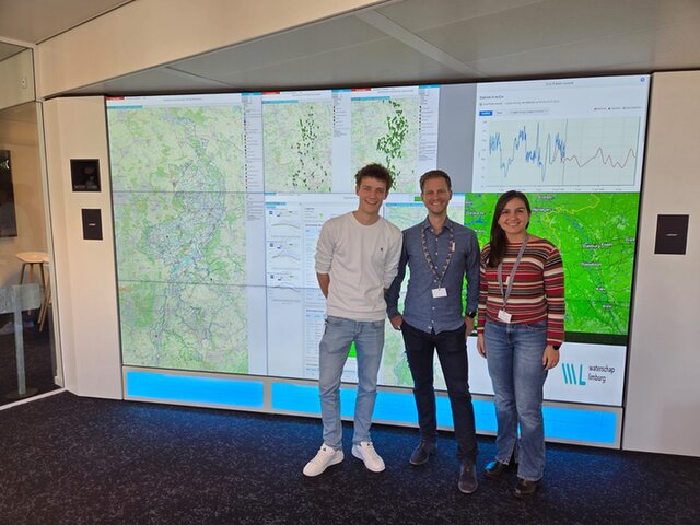
JCAR ATRACE researchers Roy Pontman, Tim Busker and Rafaella Loureiro visited the Waterschap (Waterboard) Limburg to discuss flood modelling and forecasting developments.
Impact-based forecasting (IBF) is mentioned as promising but challenging. Could you briefly describe what IBF is and how it differs from regular forecasting from the perspective of someone receiving a warning? Why is this technique promising and why is it challenging?

Conceptual representation of a flood forecasting and early warning system (FFEWS).
Conceptual representation of a flood forecasting and early warning system (FFEWS).
Jeroen
IBF differs from standard forecasts, which primarily rely on precipitation levels. For instance, if there is more than 30 millimetres of rain within a 24-hour period, a forecast is issued. Some countries and regions also issue warnings based on river water levels. The key distinction with IBF is that it also includes predictions regarding expected impacts. This is the main difference. However, in order to forecast impacts, we need detailed information about the area at risk. For example, we integrate the locations of hospitals, roads, infrastructure, and residential areas in our forecasted flooded areas. For this, we must combine data on hydrological conditions, such as water levels, with impact information. This integration of physical data and socio-economic factors is the primary challenge of IBF.
Tim
From the interviews we carried out we found out that crisis managers and emergency responders need this information to improve their operations. Moreover, IBF has the potential to improve the relationship between forecasters and stakeholders in times of crisis. IBF practices require collaboration and cooperation between many disciplines, beyond just the forecasters, but including emergency services, local governments, critical sectors (e.g. transport) and citizens themselves. Beyond improving the value of forecasts, this provides a unique opportunity to build trust between those different organisations.
Tim
On the citizen response side, our hypothesis is that the specific impact information offered by IBF leads to quicker action. For people, warnings become more serious when flood maps are included, rather than just receiving a warning like "heavy rain expected; flooding may occur in your area."
Tim
When people receive a warning message along with a predicted flood map showing that their homes are at risk, they are more likely to take the danger seriously. Although the connection between this communication method and action is still being studied, data suggests that people respond more urgently when impacts are clearly communicated. This understanding is crucial for effective emergency preparation.
We have already touched upon communication and warning levels. What are some of the biggest challenges in communicating flood risk warnings, and how do they differ between countries?
Jeroen
The biggest challenge in flood risk communication is triggering people's actions. Warnings need to motivate individuals to evacuate or take protective measures, like placing sandbags. However, this can vary significantly among different populations. Factors such as age and income play a role; for instance, older individuals may respond differently than younger ones, and poorer communities may feel less equipped to act on warnings.
Jeroen
We need to consider what types of warnings are most effective and how we can convey impact information to prompt action. Surveys can provide insights into how different messages work. For example, after a significant flood in 2021, we found that those who received warnings were more likely to act compared to those who did not. This indicates that effective warning systems can indeed lead to better preparedness and response.
Tim
It is also important to note that all countries in our study now have cell phone broadcasting for alerts, which helps communicate warnings to the mass population effectively. Unlike sirens, mobile alerts can include specific advice on what actions to take, like evacuating or using sandbags. This makes them a crucial tool for public safety during floods.
Coordination and data sharing across borders in FFEWS is important. Can you think of good examples and some regions that find this challenging?
Jeroen
In larger river basins, like the Rhine, are data sharing is more established because of the larger institutions involved. For example, we have the Transboundary Rhine Commission (ICPR), where the Netherlands and the countries of the river Rhine are cooperating. This is not the case for smaller transboundary river systems like the Geul of Vecht. In these smaller catchments we see a dependence on ad hoc cooperation between sides of the border. There are often no formal cooperations for the smaller transboundary river systems. This is where JCAR ATRACE comes in, establishing network and relationships in smaller transboundary catchments, while connecting to larger organizations such as the ICPR. Such linkages are fundamental for making data sharing easier.
You conducted this research within the JCAR ATRACE programme. How do you think this type of research fits into the programme? Did you encounter any advantages being part of this community?
Tim
I believe the JCAR ATRACE programme stands out due to its unique transboundary bottom-up approach, which distinguishes it from typical EU projects. The project’s is defined by stakeholders in countries sharing river systems: policy makers and researchers have jointly defined research questions that serve policy. Strong outreach efforts helped me significantly; people often recognised JCAR ATRACE, making it easier to secure interviews. I had no trouble engaging with over ten organisations willing to discuss their work, largely thanks to JCAR's extensive network across numerous countries. Our collaboration as a large group of authors also facilitated support and contributions across the board.
Jeroen
Cross-border cooperation is crucial, especially for smaller river systems, as information sharing during crises like extreme rainfall is vital. JCAR plays a key role by providing a platform for building long-lasting relationships and networks that promote collaboration. This initiative is unique in its capacity to foster necessary connections, and I have seen great enthusiasm from both sides of the border, highlighting the importance of shared data. Moreover, the combination of long-term, in-depth research with shorter studies has proven effective for obtaining quick results.
To close the interview about your paper: do you have any final recommendations for the readers of this magazine, such as practitioners, researchers, policymakers, etc.?
Tim
This study has proven that the close collaboration between researchers, practitioners and policymakers is essential and that our cooperation is the only way we can provide realistic and useful scientific results. We want to again thank you for this.
Jeroen
If you are interested in cross-border cooperation, please share your thoughts on institutional barriers and potential solutions. Your recommendations are valuable in overcoming these challenges.
Tim Busker
Postdoctoral Researcher at the department of Water and Climate Risk at the Institute for Environmental Studies (IVM) at the Vrije Universiteit Amsterdam