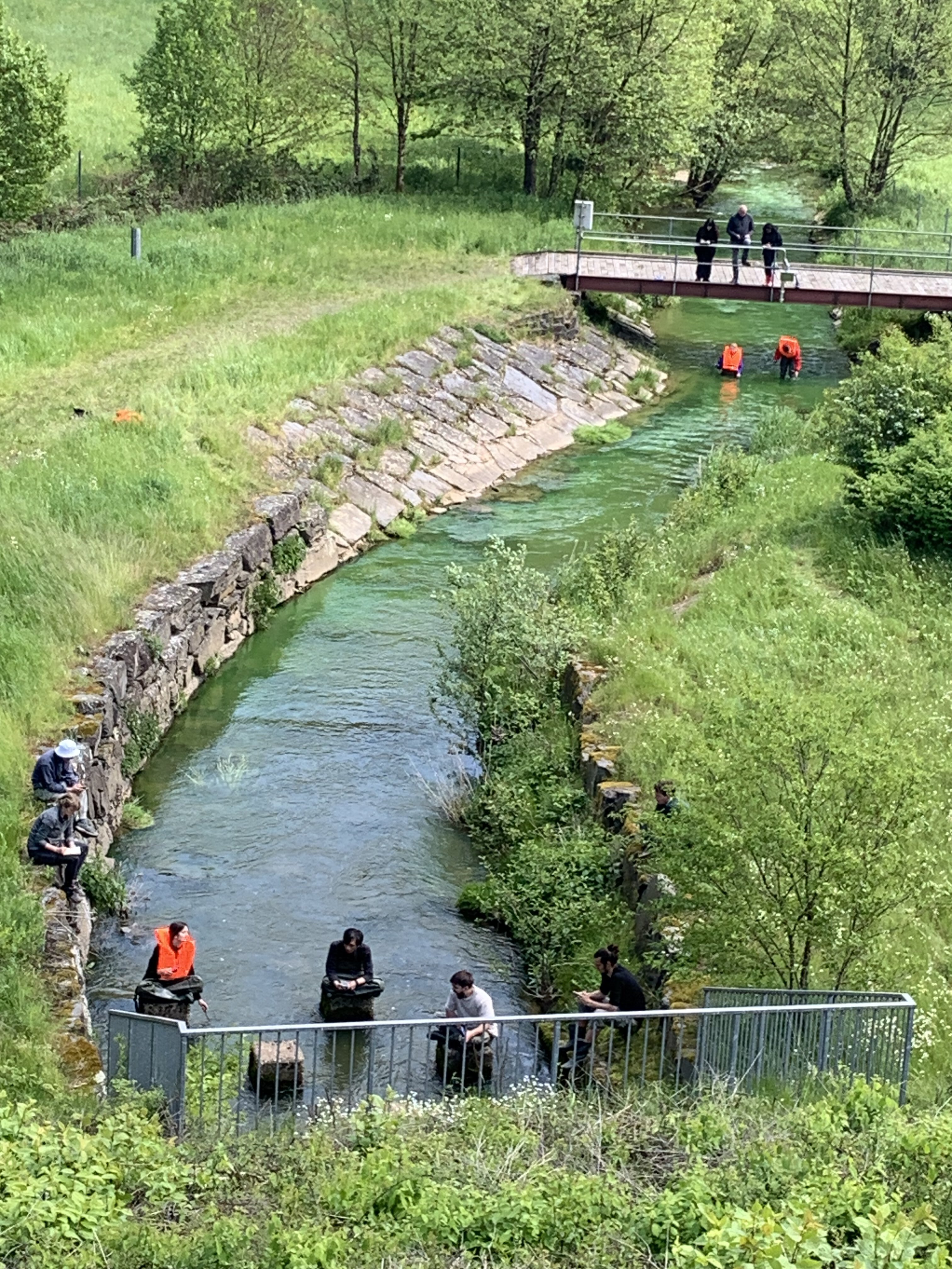
Field trip to Wark dam, Luxembourg
Research
Rapid action studies
When it comes to preparation of flood and drought management, research must adapt to the urgency and speed at which action is required. This is where the Rapid Action Team (RAT) Studies come in, providing relevant research in a timely manner.
Field trip to Wark dam, Luxembourg
Stresstest GPRW
In this study a transnational stresstest approach is developed and conducted in order to understand how water and societal systems react under extreme flood conditions, identify the points at which they fail and which actions can be taken. The goal is to prepare for unexpected and undesired situations by gaining a better understanding of the issues that arise before, during, and after extreme events.
Deltares, RWTH Aachen, TU Braunschweig, GFZ Potsdam, FloodWaive Predictive Intelligence


Deltares, RWTH Aachen, TU Braunschweig, GFZ Potsdam, FloodWaive Predictive Intelligence
Stresstest GPRW
Regions covered by the study
Vechte, Berkel, Issel
Scope & objectives
The project is supported by the Grenzüberschreitende Plattform für Regionale Wasserwirtschaft (GPRW), a cross-border platform for regional water management established in 2011. The GPRW comprises seven partners: Kreis Borken, Kreis Steinfurt, Landkreis Grafschaft Bentheim, Landkreis Emsland, and Bezirksregierung Münster from Germany, and Waterschap Rijn en IJssel and Waterschap Vechtstromen from the Netherlands. The platform focuses on collaborative efforts a.o. in flood risk management, droughts, fish migration and water quality issues.The GPRW is unique in its active cross-border cooperation along the German-Dutch border.
The joint collaboration agreement of JCAR ATRACE with the GPRW, signed in 2023, has led to the Vecht Scoping Study published in 2024, with key recommendations on joint knowledge development. One of the recommendations was to develop a transnational stresstest for the study area, an action taken up by this initiative.
Approach
In this study a transnational stresstest approach is developed and conducted in order to understand how water and societal systems react under extreme flood conditions, identify the points at which they fail and which actions can be taken. The goal is to prepare for unexpected and undesired situations by gaining a better understanding of the issues that arise before, during, and after extreme events.
Actions/Tasks
The project will be executed through a series of collaborative efforts, with a strong emphasis on workshops with the GPRW partners. Initially, the project will commence with a scoping phase, where the GPRW partners will convene to discuss and define the scenarios to be tested. The project will make use of existing flood models of the different government organisations. This ensures that all relevant perspectives are considered, particularly those of regional authorities and stakeholders.
As the models are used and validated, the project will progress to the scenario evaluation phase. Here, the team will run various stress test scenarios to assess the impacts of extreme weather events on the water systems. This phase will be marked by the second GPRW workshop, where preliminary results will be reviewed, and potential measures to mitigate identified risks will be discussed. The workshop will serve as a platform for stakeholders to provide input and refine the proposed measures.
The subsequent phase involves implementing these measures within the models and conducting further evaluations to indicate their effectiveness. The final results and recommendations will be discussed at a final and third GPRW workshop planned for later this year.
Outcomes/expected outcomes
- Modelling results in the form of flood hazard and impact maps
- A joint approach to conduct stress tests in the GPRW region
- Descriptions of the three workshops and their results
- Final report synthesizing all the findings of the project and recommendations
Next events/actions in the next 6 months
GPRW Workshop 1: Kick-off, scenarios, models Q1 2025
GPRW Workshop 2: Results, identification of measures Q3 2025
GPRW Workshop 3: Final results, recommendations Q4 2025
Angela Klein
Deltares

Transboundary capacity building JCAR ATRACE in Luxembourg
This initiative outlines a capacity building project aimed at enhancing the collaborative research and teaching efforts of the Luxembourg Institute of Science and Technology (LIST), TU Delft, and VU Amsterdam within Luxembourg. The project focuses on leveraging various locations in Luxembourg that are integral to the research and teaching programs of these institutions.
LIST, TU Delft, VU Amsterdam
LIST, TU Delft, VU Amsterdam
Transboundary capacity building JCAR ATRACE in Luxembourg
Regions covered by the study
Luxembourg
Scope & objectives
This initiative outlines a capacity building project aimed at enhancing the collaborative research and teaching efforts of the Luxembourg Institute of Science and Technology (LIST), TU Delft, and VU Amsterdam within Luxembourg. The project focuses on leveraging various locations in Luxembourg that are integral to the research and teaching programs of these institutions.
Since long (2004), TU Delft has conducted a five-day field-practical for MSc students in the Hydrology Track of the Environmental Engineering Program. This practical involves setting up, performing, and analyzing field data, linking it to theoretical coursework. Concurrently, VU Amsterdam organizes a four-week fieldwork course in Luxembourg for MSc Hydrology students. LIST plays a crucial role by providing field expertise, stakeholder connections, and hydrological data, supporting both Dutch universities' fieldwork activities.
This project aims to strengthen joint research and teaching initiatives, fostering a comprehensive understanding of hydrological processes and effective water management solutions.
Approach
To improve transboundary capacity building, two activities will be conducted: 1) organizing a joint excursion and 2) extending an existing high-resolution hydro-meteorological database of Luxembourg. Both activities focus on enhancing exchange between students from TU Delft, VU Amsterdam and LIST, and on developing a basis for future (MSc) research in Luxembourg.
Actions/Tasks
- A joint 1-day excursion will be developed to take advantage of the overlap in the two field programs by TU Delft and VU Amsterdam. It will mainly be aimed at students from TU Delft, VU Amsterdam and LIST, but also other people within the JCAR ATRACE network (such as PhD students). Key activities include developing a program for the joint excursion and involving specialists and stakeholders who will play an important role during the excursion.
- An existing high-resolution hydro-meteorological database of Luxembourg will be enhanced. This includes reorganizing the database, conducting an initial data analysis to develop MSc topics focused on long-term data series analysis, and improving accessibility of these historical chronologies.
Outcomes/expected outcomes
Building a scientific JCAR ATRACE community: These activities will strengthen ties within the scientific community around transboundary river basins through joint research and education and exchange of knowledge. The involvement of students from two Dutch institutes and Luxembourg would foster valuable connections that could greatly benefit their future careers. It is anticipated that some students will pursue their MSc theses as a follow-up to these activities under the JCAR ATRACE umbrella, contributing valuable scientific results while strengthening the JCAR ATRACE community.
Enhance scientific quality: To share, discuss, and communicate shared scientific JCAR output in order to improve scientific quality and peer review.
Connect and involve stakeholders: These activities will foster, co-develop, share and discuss scientific developments with the professional community and policy makers. Ensuring that the research conducted within JCAR ATRACE reaches the end-users.
Next events/actions in the next 6 months
The activities will take place in the period of March-June 2025. The excursion itself will take place on the 16th of May.
Davide Zoccateli
LIST
R&D activities Flood Forecasting and Early Warning NRW-NL
Several regional river basins span the border between the Netherlands and North Rhine-Westphalia. Past flood events—such as along the Oude IJssel in 2010, the Rur in 2021, and the Vecht in 2024—have demonstrated that advances in cross-border flood forecasting and early warning requires continuous attention.
Deltares, RWTH Aachen and FloodwAIve
Deltares, RWTH Aachen and FloodwAIve
R&D activities Flood Forecasting and Early Warning NRW-NL
Regions covered by the study
North-Rhein Westphalia – Netherlands (e.g. Rur, Berkel, Issel, Vechte)
Scope & objectives
Several regional river basins span the border between the Netherlands and North Rhine-Westphalia. Past flood events—such as along the Oude IJssel in 2010, the Rur in 2021, and the Vecht in 2024—have demonstrated that advances in cross-border flood forecasting and early warning requires continuous attention. While cooperation between forecasting centres, water authorities and first responders in the border region is already underway, technical and organisational knowledge exchange remains limited. To address this gap and intensify cooperation, this activity incorporates a series of joint research and development activities focused on advancing flood forecasting and early warning systems and organisations.
Approach
The project aims to build joint expert capacity, by aligning and compare operational flood models, their outputs and their interpretation, and to explore the application of advanced technologies such as artificial intelligence (AI) in flood forecasting and early warning. The AI component will be piloted in partnership with FloodWaive.
Actions/Tasks
- Working on a joint data and information base, which includes a comparison of standard hydrological forecasting and warning reports from LANUK and the Netherlands and its use by partners
- Development and use of extreme hydrological simulations and cross-border stress tests, where an experimental setup consisting of coupled operational models LARSIM NRW / SOBEK (NL) will be explored and compared to detailed model results
- Joint pilot application of AI technology for impact (affected area) and ensemble forecasts
- Sustainable joint Capacity Building and Knowledge Transfer supporting existing international government exchanges, provide additional targeted joint expert trainings and workshops, and MSc research
Outcomes/expected outcomes
- Improved operational models and water system insights: Alignment of operational models (LARSIM and SOBEK) will be explored, resulting in lessons learned to improve cross-border forecasting.
- AI-Driven Forecast Innovation: Pilot applications of AI will introduce new forecasting capabilities, particularly for impact-based and ensemble predictions.
- Strengthened Institutional Collaboration and Building Community of Practice: Structured knowledge transfer and joint training will build long-term capacity between Dutch and German authorities, open for experts from other countries
- Develop a plan for sustainable joint research and development
Next events/actions in the next 6 months
- First training on forecast-informed decision making (July or September 2025)
- Stresstesting operational models and pilot application AI-technology (2025)
Kymo Slager
Deltares
RAT-Study on water governance adaptability
The RAT study aims to develop a comprehensive understanding of the adaptability of water governance systems in the Vecht river basin. The primary objective is to make an assessment of the adaptiveness of actors in the international water governance system of the transnational Vecht watershed to prepare for and react to extreme events.
University Osnabrück, U Twente
University Osnabrück, U Twente
RAT-Study on water governance adaptability
Regions covered by the study
Vechte
Scope & objectives
The RAT study aims to develop a comprehensive understanding of the adaptability of water governance systems in the Vecht river basin. The primary objective is to make an assessment of the adaptiveness of actors in the international water governance system of the transnational Vecht watershed to prepare for and react to extreme events.
Approach
The study will be conducted through a combination of desk research, interviews, and practical analysis. Initially, an analytical framework will be developed to guide the study, ensuring a structured comparison of the Dutch and German water governance systems.
The analysis will be conducted through one or two Master theses, focusing on the planning and implementation processes related to extreme event management. This phase will involve characterizing and assessing the preparedness for and management of droughts and floods.
Interviews will be scheduled and conducted in June and July 2025, providing valuable insights from key stakeholders. These interviews will be documented and transcribed for further analysis. Additionally, a desk study will be carried out, assessing strategy papers, reports, and media coverage on the management of the chosen extreme event.
Actions/Tasks
- Develop Analytical Framework: Create a framework to guide the study and comparison of water governance systems in the Vecht river basin
- Conduct Analysis: Characterize and assess the planning and implementation processes for managing extreme events through Master theses.
- Conduct Interviews: Schedule, conduct, document, and transcribe interviews with key stakeholders.
- Desk Study: Assess strategy papers, reports, and media coverage on the management of the chosen extreme event.
- Synthesize Results: Evaluate the adaptiveness of actors in the water governance system based on the Master theses' findings.
Outcomes/expected outcomes
The main outcomes will be the Master theses and the final report describing the synthesis of the results of the RAT study. Additionally, materials will be produced such as the analytical framework, interviews and results from the desk study.
Next events/actions in the next 6 months
April – December 2025
Prof. Dr. Kim Philip Schumacher
University Osnabrück

Pluvial flooding survey (Belgium Geul)
Following the 2021 European floods, several independent data collection and survey initiatives were undertaken in Belgium and the Netherlands. These surveys aimed to assess household adaptation to flood risk, their perceptions of flood risk, and their views on new measures such as nature-based solutions.
VU Amsterdam (supported by ULiège, KU Leuven)
VU Amsterdam (supported by ULiège, KU Leuven)
Pluvial flooding survey (Belgium Geul)
Regions covered by the study
Geul
Scope & objectives
Following the 2021 European floods, several independent data collection and survey initiatives were undertaken in Belgium and the Netherlands. These surveys aimed to assess household adaptation to flood risk, their perceptions of flood risk, and their views on new measures such as nature-based solutions. However, the data were collected independently using different methods and in different areas. A survey has been developed before for the Dutch part of the Geul catchment, focusing on household valuation of nature-based solutions and socio-economic factors.
This RAT study aims to extend the survey to the Belgian part of the Geul area, enabling cross-border comparisons using a consistent methodology. Improved insights into household adaptation and risk perceptions in both countries may support more effective flood management measures.
Approach
The objective is to implement and analyze surveys in the Dutch and Belgian parts of the Geul catchment and to write a short paper in a popular magazine on cross-country differences and similarities in household flood adaptation and the effectiveness of such adaptation actions.
VU Amsterdam will lead the survey development, pilot testing, and aim for publication in a scientific journal (as part of the FRM Tech project). With additional support from JCAR ATRACE, the following activities will be executed: discussing survey questions with Belgian stakeholders, implementing the survey in the Belgian parts of the Geul, and publishing the results in a popular news article.
Actions/Tasks
- Survey Development: Discuss the survey questions with Belgian stakeholders to ensure they address key aspects of household adaptation, risk perceptions, and nature-based solutions.
- Survey Implementation: Implement the survey in the Belgian parts of the Geul catchment
- Data Analysis: Analyze the collected data to identify cross-country differences and similarities in household flood adaptation and risk perceptions.
- Publication: Publish a joint popular news article, summarizing the findings and highlighting the implications for flood management measures.
Outcomes/expected outcomes
This research aims to support governments in developing more effective flood management strategies, enhancing resilience against future flood events.
The expected outcomes of this study include a comprehensive understanding of household adaptation activities and risk perceptions in the Geul catchment in Belgium and the Netherlands. The results will provide valuable insights into the effectiveness of nature-based solutions and other flood management measures.
Next events/actions in the next 6 months
1 February 2025 till 1 October 2025 |
Laurine de Wolf
Vrije Universiteit Amsterdam
Acceptance of measures between upper and lower riparian owners
The project aims to address the critical issue of acceptance of flood risk measures, especially in upstream areas that safeguard downstream regions.
RWTH Aachen (supported by Deltares)
Acceptance of measures between upper and lower riparian owners
Regions covered by the study
Rur
Scope & objectives
The project aims to address the critical issue of acceptance of flood risk measures, especially in upstream areas that safeguard downstream regions.
In upstream areas, flood retention areas are planned, but the benefits are primarily for downstream residents. Acceptance in upstream and often rural areas is low because, for example, farmers and foresters have to make land available for retention areas or convert landscapes into sponge areas. Not only do they have to make land available, they also have to accept a loss of income.
Therefore, some kind of (monetary) compensation for planning, construction and operation would make sense in order to increase acceptance, gain time and turn flood protection into an economic benefit.
Approach
The approach involves a review and analysis of existing flood protection measures and methodologies in the transboundary region to understand their effectiveness and acceptance levels. The project will begin with a literature review, examining both micro and macro perspectives on flood risk strategies.
Following the literature review, interviews with relevant stakeholders, including farmers, foresters, and local authorities, will be conducted to gather insights and opinions on flood risk measures and compensation schemes.
Based on the findings from the literature review and interviews, an overview of existing approaches will be created, along with suggestions for an approach aimed at increasing acceptance of flood risk measures.
Actions/Tasks
The following tasks will be conducted:
- Literature review on existing approaches (micro to macro view)
- Interviews with relevant people and organizations
- Overview of existing approaches and suggestion for methodology
- Creation and revision of study report
Outcomes/expected outcomes
The expected outcomes of the project include a detailed understanding of the factors influencing the acceptance of flood risk measures in upstream areas and the development of a methodology/approach to enhance this acceptance.
Next events/actions in the next 6 months
Period of July till December 2025 |
Elena-Maria Klopries
RWTH aachen